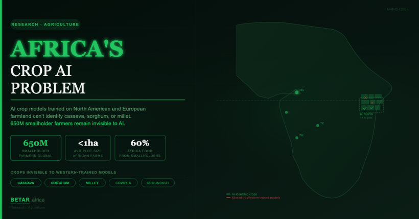
When Catherine Nakalembe set out to map crop types in western Kenya using satellite imagery, she ran into a problem that no amount of computing power could solve: the AI models did not know what a cassava plant looked like. The tools available had been trained on North American and European farmland. They could identify wheat fields in Kansas and barley in Bavaria. Maize and sorghum in the smallholder plots of western Kenya — plots averaging less than a hectare, interspersed with kitchen gardens and fallow strips — were largely invisible to them.
Nakalembe’s solution was distinctly low-tech. Her team mounted GoPro cameras on motorcycle helmets and paid volunteers to ride through farming communities, collecting ground-truth images that could be used to train a model from scratch. The technique — later formalised as “Helmets Labeling Crops” through NASA Harvest, where Nakalembe serves as Africa Programme Director — has since been replicated in Mali, Rwanda, Tanzania, and Uganda. It works. But it is also a signal of how wide the gap is between what AI agriculture tools can do in the Global North and what they can do on the continent where agriculture still employs 60 percent of the workforce.
The broader phenomenon was documented in a March 12 piece by Rina Chandran for Rest of World, which described how Western AI models fail “spectacularly” in farms and forests across the Global South. Kenya features as a primary African case study. But the story that piece points toward — which tools are actually working in Africa, who is building the data infrastructure underneath them, and what it would take to close the gap at scale — is a longer one.
Three Structural Failures
The AI localisation gap in African agriculture is not one problem. It is at least three, compounding each other.
The first is the crop variety gap. The dominant global training dataset for plant disease detection — PlantVillage, which underpins dozens of crop AI tools deployed worldwide — was assembled primarily from North American crops under controlled laboratory conditions. African staple crops: cassava, sorghum, millet, teff, cowpea, finger millet, and the hundreds of local varieties of each, are sparsely represented or absent entirely. A 2025 systematic review published in ScienceDirect noted “a disproportionate concentration of databases from Asia compared to other regions,” with Africa and South America underrepresented, creating models with “limited generalizability to other areas with different cultural, climatic, and pest and disease pressures.”
The second is the soil type gap. Most machine learning soil models were built on European and North American training data — the EU’s LUCAS Soil Survey dataset, the USDA’s survey network. Africa’s dominant soil types — laterites, ferrasols, vertisols, nitisols — have fundamentally different spectral signatures, nutrient profiles, and water retention properties from the temperate soils on which global models are calibrated. Applying a European soil nutrient model directly to an East African context typically requires extensive supplementary local data to produce reliable outputs, according to multiple peer-reviewed assessments reviewed by BETAR.africa.
The third is the satellite resolution gap — and it may be the least discussed and most structurally significant. The most widely used free satellite, Sentinel-2, provides imagery at a maximum of 10-metre resolution. A single pixel covers 100 square metres. Approximately 50 percent of farms in sub-Saharan Africa are smaller than 0.4 hectares (4,000 square metres), according to a 2021 ScienceDirect review of satellite-based agricultural monitoring in Africa. The average Kenyan smallholder farm covers 0.5 to 2 hectares. A 100-hectare US farm has roughly 10,000 Sentinel-2 pixels for a model to work with. A 0.4-hectare Kenyan plot has 40.
African smallholder farms also commonly use intercropping — multiple crops planted together in a single field — which creates mixed spectral responses that confuse standard crop-classification algorithms built on the assumption that one field equals one crop type.
What Africa-Native Tools Look Like
A handful of companies have taken the approach of building from the ground up on African data rather than attempting to adapt Western models.
Apollo Agriculture, founded in Nairobi in 2016 by Eli Pollak and Benjamin Njenga, processes satellite field coordinates, local soil data, farmer behaviour patterns, and historical crop yield data to generate individualised credit profiles for unbanked smallholder farmers. Rather than applying models built on Western precision agriculture data, Apollo assembled its own Africa-specific training dataset over several years of operations in Kenya. The company has reached more than 350,000 farmers, offering input packages, crop insurance, and agronomic advisory services. Average farm production among Apollo clients is reported at 2.6 times higher than comparable non-client Kenyan farmers. A $40 million Series B in 2022, led by SoftBank with participation from the Chan Zuckerberg Initiative, validated the commercial model.
iSDA (Innovative Solutions for Development of Agriculture) built the continent’s first field-level soil map for Africa at 30-metre resolution, trained on more than 100,000 analysed African soil samples covering 20 or more soil properties. The iSDAsoil map, published in peer-reviewed form in PMC, is now the reference dataset for Africa-specific soil AI. iSDA’s “Virtual Agronomist” advisory service, accessible via WhatsApp, covers 17 African crop types including cassava, sorghum, millet, and cowpea — explicitly the crops that global models neglect. Reported yield improvements from randomised controlled trials: 1.7 times for maize in Uganda, 1.9 times for sorghum in Uganda, 1.7 times for sunflower in Tanzania, 1.4 times for maize in Côte d’Ivoire. Over 250,000 farmers across seven countries have received tailored recommendations via the platform.
In Nigeria, Zenvus — founded by Professor Ndubuisi Ekekwe — deploys proprietary in-ground soil sensors measuring pH, moisture, nutrients, and temperature in real time, feeding a cloud advisory model built on locally collected African soil data. The platform covers more than 500,000 farming entities across Nigeria, Botswana, Ghana, and Rwanda. Its soil data is not transferred from any temperate-zone baseline; it is the baseline.
For plant disease detection, PlantVillage at Penn State University — led by Professor David Hughes — developed Nuru, a smartphone application specifically designed for cassava disease identification that works entirely offline in field conditions. Independent field studies in East Africa found Nuru diagnostic accuracy at 65 percent, rising to 74–88 percent with a standardised six-leaf sampling protocol. Human agricultural extension agents in the same field conditions performed at 40–58 percent accuracy; farmers themselves at 18–31 percent. The comparison is not flattering in absolute terms — 65 percent is a long way from the 90-plus percent accuracy reported in lab conditions — but it illustrates both the ceiling that field conditions impose and the floor that Nuru lifts farmers above.
Note: Twiga Foods — a Nairobi produce platform that had integrated AI crop-prediction tooling — is not profiled here. The company halted operations in June 2025 and its current status could not be verified at publication.
The Dataset Infrastructure Race
Behind these individual tools is a more foundational problem: the training datasets for Africa-specific agricultural AI do not yet exist at the scale required.
Bridging that gap has become a named priority for several institutions. CGIAR’s GARDIAN data repository has published more than 65,000 agricultural research publications as an AI-ready dataset, covering small-scale producers in low- and middle-income countries. CGIAR’s Carob Database contains nearly 2,300 standards-compliant agronomic datasets representing more than two million global records, with a majority in Africa. The GROW-Africa database, published in Nature Scientific Data in 2025, provides 535,844 geo-referenced historical crop yield observations across 25 African crops including cassava, millet, sorghum, and teff — sourced from government statistics, farmer surveys, and local farm-scale data collection across the continent.
The Lacuna Fund, co-founded by the Rockefeller Foundation, Google.org, and Canada’s IDRC in 2020, was specifically created to fill training data gaps in ML models for underserved communities. As of July 2025, leadership transferred to African and Latin American institutions — including the African Centre for Technology Studies (ACTS) in Nairobi, Masakhane, and the University of Pretoria Data Science for Social Impact group. Zindi, Africa’s ML competition platform, has run multiple Africa-specific agricultural AI challenges, including the Ghana Crop Disease Detection Challenge and the CGIAR Crop Damage Classification Challenge, generating labelled datasets while simultaneously developing local AI talent.
The CGIAR AICCRA project’s analysis of iShamba — a Kenyan agri-advisory service — used 5.5 years of farmer query data (2020–2025) to surface something that pure technical benchmarks miss: AI advisory systems in Africa also fail because of language and literacy gaps, not just soil and crop data gaps. The analysis identified “language and literacy-related issues, prevalence of very short queries, content duplication, and regional usage disparities” as factors that cause well-designed models to systematically exclude the farmers most in need of advisory services. Digital Green’s FarmerChat, which delivers generative AI agricultural advice in Swahili, Hindi, and expanding local languages to more than 830,000 users across Kenya, Nigeria, Ethiopia, and South Asia, represents the current operational frontier on this dimension.
Performance Comparison: Western Baseline vs Africa-Validated Models
| Application | Western/Global Model Performance | Africa Field Performance | Notes |
|---|---|---|---|
| Cassava disease detection (PlantVillage Nuru) | 90%+ in lab conditions | 65% in East Africa field studies; 74–88% with 6-leaf protocol (Frontiers in Plant Science, 2020) | Gap driven by field lighting, crop variety diversity, disease stage variation |
| Forest/tree cover detection | ~90% in North American training environments | Less than 50% in sub-Saharan application — “missed over half the trees” (Rest of World, March 2026) | Model retrained from scratch on manually annotated 55,000-tree African drone dataset |
| Crop type mapping (satellite, Sentinel-2) | High accuracy in US/EU single-crop fields | Not deployable without new ground-truth data collection in Kenyan context (Nakalembe / NASA Harvest) | Intercropping and plot size below satellite resolution threshold |
| Soil nutrient prediction | High accuracy in temperate zones (LUCAS/USDA data) | Requires Africa-specific supplementary data; direct transfer fails (AgroLens field experience) | Laterite and vertisol soil types absent from Northern training sets |
| AI weather forecasting (smallholder scale) | High global accuracy; models trained on dense Northern station networks | Coarse resolution for sub-1ha plots; African meteorological station network sparse | AfriClimate AI/Forecast4Africa addressing this with Africa-specific fine-tuning |
The Policy Gap
The African Union’s CAADP Strategy and Action Plan 2026–2035, adopted at the Kampala Summit in May 2025, is the continent’s most detailed agricultural development framework to date. It explicitly recognises AI and biotechnology as tools to improve productivity and climate resilience, and calls for a continental Data Policy Framework to “strengthen and harmonise data governance frameworks in Africa and thereby create a shared data space.” The AU–Google AI partnership signed in February 2026 uses the language of “sovereign AI” in the context of building African digital capacity.
What neither document does is mandate that AI tools deployed for African agriculture be trained on African data. The gap between the policy aspiration — sovereign AI, harmonised data governance, African-owned datasets — and the current operational reality — where most deployed AI agriculture tools still transfer-learn from Western training sets — represents the continent’s most significant unaddressed structural risk in agricultural technology.
The irony is precise. Africa is where AI in agriculture could deliver the highest impact: the yield gap between current smallholder production and potential yield on African land is larger than anywhere else in the world. Africa is also where the training data infrastructure is thinnest, the resolution mismatch is greatest, and the crop and soil diversity is most distant from the datasets on which available tools were built. The tools calibrated to transform livelihoods at scale are still calibrated to fields 10,000 kilometres away.
Closing that gap — dataset by dataset, sensor reading by sensor reading, GoPro camera mounted on a motorcycle helmet — is the work currently underway. It is slow. It is underfunded relative to its importance. And it is the precondition for every AI agriculture investment the continent will make in the next decade.
— Research Reporter, BETAR.africa